Log in
All resources
Create a design
339 Free Artworks of 1700 Maps
bibliothèque nationale de france
eran laor cartographic collection
maps by pieter mortier
maps by alexis-hubert jaillot
lawrence h. slaughter collection of english maps, charts, globes, books and atlases
carte de l'amérique septentrionale by guillaume delisle (1700)
french-language maps
maps from gallica
latin-language maps
1700s maps of italy
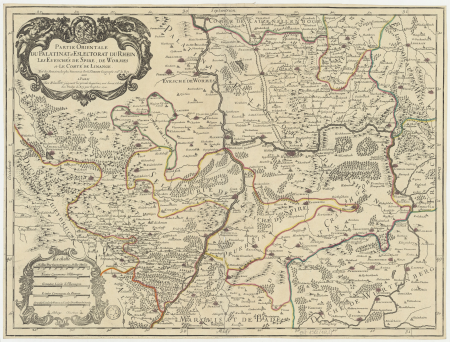
1700s maps of the holy roman empire
maps by joachim bormeester
eran laor cartographic collection
pierre aveline
maps in the library of congress
18th-century maps of sumatra
map of amsterdam by julius milheuser after daniël stalpaert, 1662
julius milheuser
18th-century maps of veneto
1700s maps of slovenia
maps of paris from bibliothèque nationale de france
plan de roussel
map of the circle of austria by sanson
1700s maps of austria
lucas achtschellinck
baroque
map of the circle of austria by sanson
1700s maps of austria
maps of the iberian peninsula by guillaume delisle
1700s maps of the iberian peninsula
maps of paris from the david rumsey historical map collection
map of paris by jouvin de rochefort (boutier 133)
lawrence h. slaughter collection of english maps, charts, globes, books and atlases
nypl lionel pincus and princess firyal map division
old maps of the republic of genoa
maps by alexis-hubert jaillot
old maps of the republic of genoa
maps by alexis-hubert jaillot
bibliothèque nationale de france
sanson map of lorraine
eran laor cartographic collection
sanson maps of asia
map of the circle of austria by sanson
1700s maps of austria
bibliothèque nationale de france
sanson map of lorraine
bibliothèque nationale de france
sanson map of lorraine
map of the upper rhenian circle by sanson
1700s maps of north rhine-westphalia
eran laor cartographic collection
pierre aveline
maps in the library of congress
1769 maps of europe
details of old maps
michael burghers
18th-century maps of veneto
1700s maps of slovenia
maps of the iberian peninsula by guillaume delisle
1700s maps of the iberian peninsula
sanson maps of the netherlands
robert cordier (engraver)
maps by pieter mortier
old maps of asia
maps of algiers by braun & hogenberg
maps of the iberian peninsula by guillaume delisle
1700s maps of the iberian peninsula
maps of the iberian peninsula by guillaume delisle
1700s maps of the iberian peninsula
lawrence h. slaughter collection of english maps, charts, globes, books and atlases
1700 maps of the atlantic ocean
lawrence h. slaughter collection of english maps, charts, globes, books and atlases
1700 maps of the atlantic ocean
maps from the earth and its inhabitants, vol. xii
africa in the 1890s
carte de l'amérique septentrionale by guillaume delisle (1700)
1700 maps of north america
eran laor cartographic collection
cornelis de bruyn
maps in the stadsarchief amsterdam
daniel stoopendaal
1700s maps of rhineland-palatinate
maps of vangiones by sanson
lawrence h. slaughter collection of english maps, charts, globes, books and atlases
nypl lionel pincus and princess firyal map division
maps by pieter mortier
maps from gallica
nicolaes visscher ii
maps from gallica
map of italy by guillaume delisle (1700)
bibliothèque nationale de france
eran laor cartographic collection
pierre mortier
eran laor cartographic collection
pierre mortier
map of italy by guillaume delisle (1700)
1700 maps of italy
1700s maps of the tsardom of russia
1700s maps of eastern europe
eran laor cartographic collection
cornelis de bruyn
eran laor cartographic collection
cornelis de bruyn
18th-century maps of corsica
maps by thomas kitchin
a new map of the island of tobago... - by tho.s kitchin... - btv1b53121990k
maps by thomas kitchin
maps by pieter mortier
maps from gallica
a new map of the island of tobago... - by tho.s kitchin... - btv1b53121990k
maps by thomas kitchin
broadsheet prints from koninklijke bibliotheek - maps
broadsheet prints from koninklijke bibliotheek
antoine-françois tardieu
maps from gallica
broadsheet prints from koninklijke bibliotheek - maps
broadsheet prints from koninklijke bibliotheek
broadsheet prints from koninklijke bibliotheek - maps
broadsheet prints from koninklijke bibliotheek
1700s maps of rhineland-palatinate
maps of east palatinate by sanson
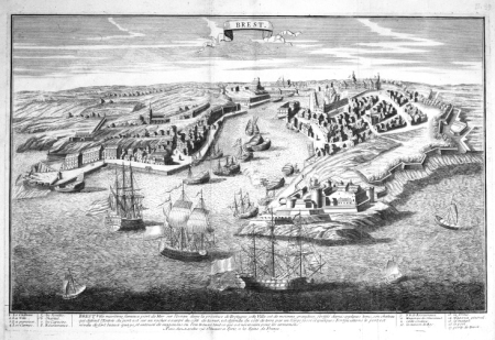
maps of brest from bibliothèque nationale de france
brest (france) in the 1700s
maps by alexis-hubert jaillot
old maps of duchy of cleves
lawrence h. slaughter collection of english maps, charts, globes, books and atlases
nypl lionel pincus and princess firyal map division
mappe-monde by guillaume delisle (18th century)
1700s maps of the world
maps by pieter mortier
maps from gallica
18th-century maps of the indian ocean
18th-century maps of southeast asia
eran laor cartographic collection
pierre mortier
maps by pieter mortier
old maps of genoa
maps in the british museum
jan baptist berterham
atlas van der hagen (volume 3)
atlas van der hagen
media contributed by university of illinois urbana-champaign university library
carte du mexique et de la floride by guillaume delisle (1703)
bibliothèque nationale de france
maps by thomas kitchin
french-language maps
1742 maps
old maps of kraków
pierre aveline
lawrence h. slaughter collection of english maps, charts, globes, books and atlases
covens en mortier
maps by alexis-hubert jaillot
maps by guillaume sanson
maps by guillaume sanson
maps of galatia
johann stridbeck the younger
old maps of the tyrol
map of europe by guillaume delisle (1700)
bibliothèque nationale de france
bibliothèque nationale de france
maps by thomas kitchin
carte de moscovie by guillaume de l'isle (1706)
1700s maps of russia
historical maps of crema
borgo san pietro (crema)
eran laor cartographic collection
pieter van der keere
maps in the rijksmuseum amsterdam
17th-century maps of prussia
nicolas henri jeaurat de bertry
oil on canvas
lawrence h. slaughter collection of english maps, charts, globes, books and atlases
nypl lionel pincus and princess firyal map division
old maps of the kingdom of naples
lago patria
maps by willem and johannes blaeu
1630s maps of the caucasus
dessin du château de brest
old maps of brest harbours
johann christoph brotze
old maps of narva
maps by pieter mortier
maps from gallica
eran laor cartographic collection
gerard valck
mappe-monde by guillaume delisle (18th century)
claude auguste berey
maps by alexis-hubert jaillot
old maps of the tyrol
broadsheet prints from koninklijke bibliotheek - maps
broadsheet prints from koninklijke bibliotheek
paintings in unidentified private collections
paintings by richard brakenburgh
sanson maps of the netherlands
1700s maps of the netherlands
prints by jan luyken in the rijksmuseum amsterdam
maps in the rijksmuseum amsterdam
media contributed by university of illinois urbana-champaign university library
carte de barbarie, nigritie, guinée par guillaume delisle (1707)
eran laor cartographic collection
pierre mortier
map of the circle of austria by sanson
maps by nicolas sanson
old maps of the kingdom of naples
maps by alexis-hubert jaillot
lawrence h. slaughter collection of english maps, charts, globes, books and atlases
covens en mortier
maps by pieter mortier
maps from gallica
101 - 200 of 339
Next page
/ 4


![Map of Paris ([Reprod. in facsim.]) / by Roussel, engineer in 1700, 1730](https://cdn.creazilla.com/illustrations/10001522196/map-of-paris-reprod-in-facsim-by-roussel-engineer-in-1700-1730-md.jpg)


![North America: based on the observations of Mrs. de l'Académie Royale des Sciences & some others, & on the most recent memoirs, 1700 [i.e. 1708]](https://cdn.creazilla.com/illustrations/10001447935/north-america-based-on-the-observations-of-mrs-de-lacadmie-royale-des-sciences-some-others-on-the-most-recent-memoirs-1700-ie-1708-md.jpg)


![Stadsprofiel van] ROMA, 1704](https://cdn.creazilla.com/illustrations/10000357441/stadsprofiel-van-roma-1704-md.jpeg)